Jackson Park Outfall Rehabilitation
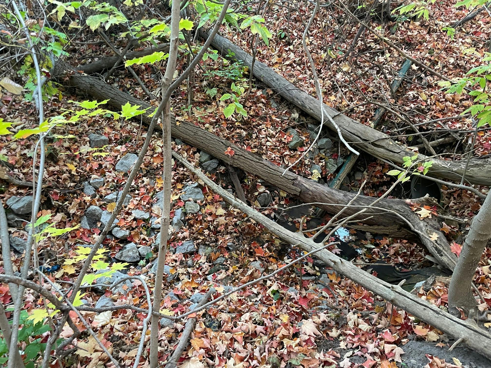
The City of Peterborough and Water's Edge Environmental Solutions Team Ltd. is working to repair the channel which carries stormwater from an outlet on the north side of Parkhill Road and east of the Jackson Park entrance, down into Jackson Creek. The area is experiencing erosion, debris build-up, and a degraded culvert passing beneath the pedestrian trail.
The Issue:
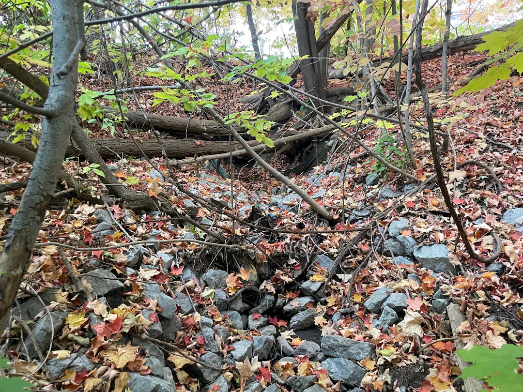
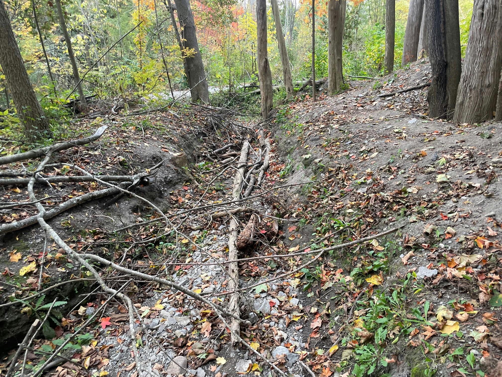
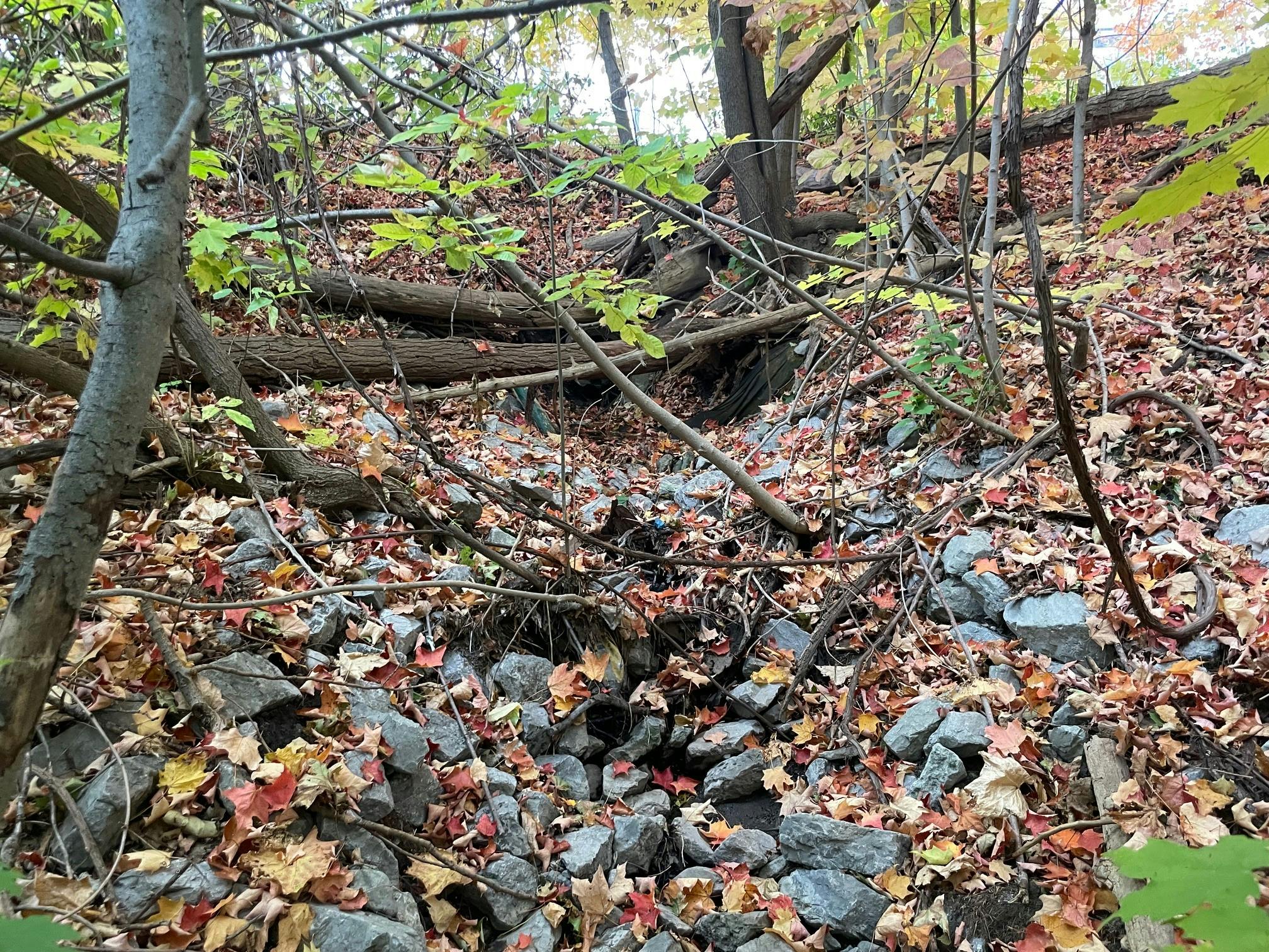
Stormwater from Parkhill Road near its intersection with Monaghan Road flows into street storm drains and is discharged through a pipe, down a steep slope. Due to the slope and sandy soils, the area is actively eroding, causing damaged banks, exposed roots, and fallen trees, leading to a generally unappealing and low-functionality channel. The goal of the project is to design a new outfall which will convey flow more effectively, limit further erosion, and provide improved habitat and scenery.
 Map of the work area
The Opportunities:
The are several options being considered to address this issue, each with their own benefits and drawbacks. Some of the alternatives are laid out broadly below.
Alternative 1: Leave it be.
Pros: No immediate cost. Cons: Prone to further issues, ongoing maintenance and threat to pedestrian trail, and poor habitat and scenery.
Alternative 2: Drop Pipe and Natural Channel Design. Add a drop structure and pipe which discharges close the bottom of the existing slope and fill a portion of the current corridor. Implement a natural channel between the new outflow pipe and Jackson Creek with an upgraded culvert beneath the pedestrian trail.
Pros: Limits erosive flows, limits threat to pedestrian trail, and gives a naturalized look. Cons: Some filling of corridor and higher upfront costs.
Alternative 3: Spillway and Natural Channel Design. Maintain the existing outflow pipe with a new concrete headwall. Stabilize the current spillway/channel with stone and/ or step pool structures. Implement a natural channel between the new outflow pipe and Jackson Creek with an upgraded culvert beneath the pedestrian trail.
Pros: No filling of corridor, limits threat to pedestrian trail, very naturalized look, moderate upfront cost. Cons: Long-term erosion concern, debris blockage concern.
Voice your opinion:
Comments are welcome using the comments section below. The closing date for public comments is Thursday, April 30.
Please reach out to the contacts in our "Who's Listening" section if you have any questions, comments or concerns. A wide variety of perspectives will contribute to a well justified and broadly satisfying solution.
Thank you for the opportunity to comment.
I will start with echoing Dylan Radcliffe’s request to protect the areas that we’re improved by the community recently in the planning and with exclusion fencing. One uninformed heavy equipment operator dumping a load of material could wipe out much of the work: grants written, city permission obtained, tree seedlings obtained, invasives removed, piles of compost and wood chips moved by wheelbarrow by from Bonaccord, crews of volunteers (seniors to children) working hard, first aid/refreshments, event planning, ongoing watering and weeding. Please get a site plan from Dylan and don’t disappoint again with careless adjacent work.
As an advocate for Jackson Park I would like the rehabilitation to be as natural as possible, hopefully even an enhancement, and therefore I advocate for a careful and maintained Spillway and Natural Channel Design (alternative 3). I watched the improvement to the outfall at 31 Parkview Drive in 2021 with interest and visited it as recently as today and will use it as a reference point. The Parkview outfall is much larger than that outfall being rehabilitated in this project and yet it shares several common features: a vertical drop, flowing water, sediment introduced from road treatments, downstream problems in the form of culvert and open drains being filled to overwhelm and then washing out of pathways.
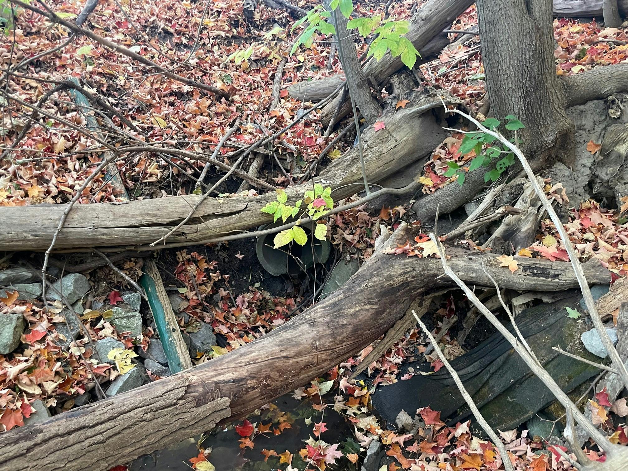
The outfall site under study is about 60 years old and appears to have been minimally maintained. There is some reasonably freshly installed riprap on the immediate area of the outfall pipe and then some evidence of emergency clearing of the watercourse. Every year storms and melt carry water fresh and road sand from the catchment area. The storm sewer catchbasins are located on the hill of Parkhill Road to the west all the way past Medical Drive (not just Monaghan Rd as mentioned on the webpage). The other significant areas served by this area of the storm drain system are the parking lots around Belmont Towers, the Parkhill Place townhome complex and the Jackson Park parking lot. Hills are heavily treated for traction as needed. The Park parking lot regularly erodes. I assume adjustments to the sources of road sand that end up in the drainage area and Jackson Park are out of scope of this project so the solution must deal with that ongoing, annual input.
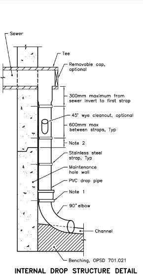
The resource documents for alternative 2 that accompany the project show an internal drop structure detail that is fastened to a wall. No such wall exists on site since the Parkhill bridge approaches are built up aggregate so this particular image isn’t suitable to the site. More generously the suggestion would be to image the outfall pipe extended until much of the vertical distance has been covered so that the water flow would not pick up additional speed once it was unconstrained in an open drain. Adding such a pipe underground seems like it is beyond the available budget and would require significant disturbance and adding it above ground would not be esthetically pleasing in a park setting.
The 31 Parkview Dr outfall and solution is much larger in every dimension. The rocks used to create the solution required full size crawler excavators (in precarious positions sometimes). It was surprising so see this huge equipment being used. With the Parkhill Road outfall being much smaller hopefully more delicate equipment can be employed so that the worksite remains focused.
The vertical drop below the 31 Parkview Dr outfall is much greater and the water course has been designed with large round boulders to break up the flow. At the end there is a rock wall with a bit of a flat area upstream. Once the water has fallen down that rock wall the water course has not been modified. 5 years after construction, while still working as designed, road sand deposits are already evident anywhere the flow slows down. The flat area serves as a small settling pond. It is now only a couple of inches deep since it has worked as designed. But in coming years it will have diminishing capacity to collect material and without maintenance / cleanout the sediment will not be able to stop here and will continue downstream.
The 31 Parkview Dr intervention connect to park infrastructure in the same way that the outflow in this project does – a pathway is getting washed out because downstream open drains and culverts are not working – ie they are filling up with sediment.
Water flows relentlessly, carrying with it sediment. Sediment will continue to be provided upstream of the outflow. Maintenance is a requirement but I doubt it is part of this capital project. Are you hoping for an engineered solution that will last another 60 years?
Below the 31 Parkview Dr intervention that watercourse used to stay north of the railway line and empty into the top of the mill pond in Jackson Park. It went through a large wetland area roughly below 11-19 Parkview Dr and then through a culvert under the gravel road (all north of the main trail). Due to lack of maintenance the wetland partially filled in and a culvert was created to allow the water to go under the trail to the creek. The watercourse filled in near the culvert and again breached the path and a triple culvert was added further upstream but the watercourse open drain / ditch was not maintained. ORCA has recently done some work adjusting the watercourse beside the trail and installed yet another culvert under the trail because they have concluded the existing sedimentation will continue. This cannot be regarded as effective water management and maintenance. Let’s iterate in a better direction this time.
The outflow rehabilitation of this project is needed. There are opportunities to create a stepped flow that slows the water down and reduces erosion caused by fast flow. The steps can be designed to create microwetlands that will be subject to dry periods (so that’s tricky) and to allow for new vegetation to be planted. The culvert can be improved so water faithful follows it instead of overtopping and washing out the path. All good but better done with minimized impact during installed and a maintenance plan.
Finally there is the challenge of public work in undefended spaces. There is currently a fallen log immediately below the outfall that is among the riprap and it has slowed the flow leading so sediment and leaf litter build up so that the watercourse had changed is now flowing in a new path over the roots of a tree which will become the next fallen log. Exploratory children have been observed actively collecting wood and intentionally plugging the upstream end of the culvert. Just in the last week or two someone had a project they wanted to undertake and now there is a collection of 20 or so pieces of riprap up on the lawn area of the park instead of where it was originally placed at the outfall. What if there was maintenance for these kinds of incidents as well. Jackson Park used to have a caretaker – the cottage where he lived is right there at the gate. Jackson Park has a community of users who could be engaged as stewards but the city has no model or encouragement for such groups and it is floundering.
So… Spillway and Natural Channel Design (alternative 3) is preferred, being careful of adjacent community group, with minimally invasive equipment and with a maintenance plan. I am unclear what the new concrete headwall mentioned adds to this approach except that is it probably updated code (and CO2 emissions).
Thanks again. Can we do the outfall roughly opposite 851 Valleyview Dr next?
It would seem that the issues primarily relate to velocity, slope, and erosion; it can also look at reducing stormwater contamination of the Creek.. It will be important to look at the entire catchment area of the storm sewer for system solutions. There may be upstream opportunities to reduce and delay storm flow, or potentially to split sources. Perhaps create a small settling pond on or just downslope of the upper terrace to collect and slow some or all of the storm flow and let it more gradually release to the Creek in off-peak times. It is preferable to use natural materials for the aesthetics of the Park and to ensure a regular maintenance and more immediate response protocol. Restoration of the understory and trail management will be important here to address erosion and sedimentation in the area, as well as protecting the existing tree restoration area. In this project also consider including drainage from the Parkhill Bridge that currently goes directly into Jackson Creek (the down pipes could collect runoff), along with considerable salt, sand, oils and small debris (e.g. brake pad and rubber bits), adding unfiltered contaminants to a major watercourse. Once initial public comments are collected, it would be useful to have a public site visit with staff and consultants to engage in information sharing and solution generation.
Please make provisions for and note on your construction drawings the location of the 80 trees that were planted adjacent to the trail in 2024 to prevent damage where possible. Ideally exclusion fencing or sediment barrier would be installed around the extent of these plantings.
There have been attempts to stabilize the channel in the past by installing rock check dams. These check dams have rapidly degraded due to the accumulation of sediment (likely due to road sand / salt deposits) A drop pipe connection to a natural channel will likely be much more successful in long term in maintaining the stability of the channel.
For channel stabilization, please consider the use of natural cribbing material combined with live stake plantings of shade tolerant species. There is an abundance of nearby logs from the 2025 ice storm that could be utilized in the construction of natural cribs.
I would also like to note that this is adjacent to two of the main entrances to Jackson Park and that consideration for aesthetics should be a high priority.